Bicycle Accessibility to Railway Stations in Wrocław
A network analysis showing the bicycle travel range to main railway stations in Wrocław within 5, 10, and 15 minutes
Introduction
Wrocław, with its unique geography and numerous watercourses, presents a fascinating subject for analyzing bicycle accessibility to various locations, including railway stations. I chose Wrocław for this analysis due to its significance as a major Polish city and growing interest among cyclists.
Cyclists have become an integral part of Wrocław's urban landscape, increasingly engaging in sustainable and eco-friendly transportation. Railway stations serve as key destinations for cyclists, functioning as transit hubs and departure points for train journeys.
Research Objective
Optimizing bicycle access to railway stations is crucial for improving residents' quality of life and reducing traffic congestion and greenhouse gas emissions in the city.
Methods
Data Sources
For this analysis, I used geodatabases and OpenStreetMap data obtained from BBBike. Data on railway station locations were filtered from the "Wroclaw_osm_pt" layer, selecting records where the "railway" column was marked as "station".
Analytical Tools
The analysis was conducted using the "Service Area" tool in ArcGIS Pro. This tool is designed for analyzing road or route networks, allowing the determination of areas reachable within specified travel times or distances from selected destination points within a given network.
Preparation of road network data and station locations
Configuration of analysis parameters (direction: Toward facilities, geometry: Dissolve)
Conducting analysis for different travel times (5, 10, 15 minutes)
Visualization of results on maps
Results
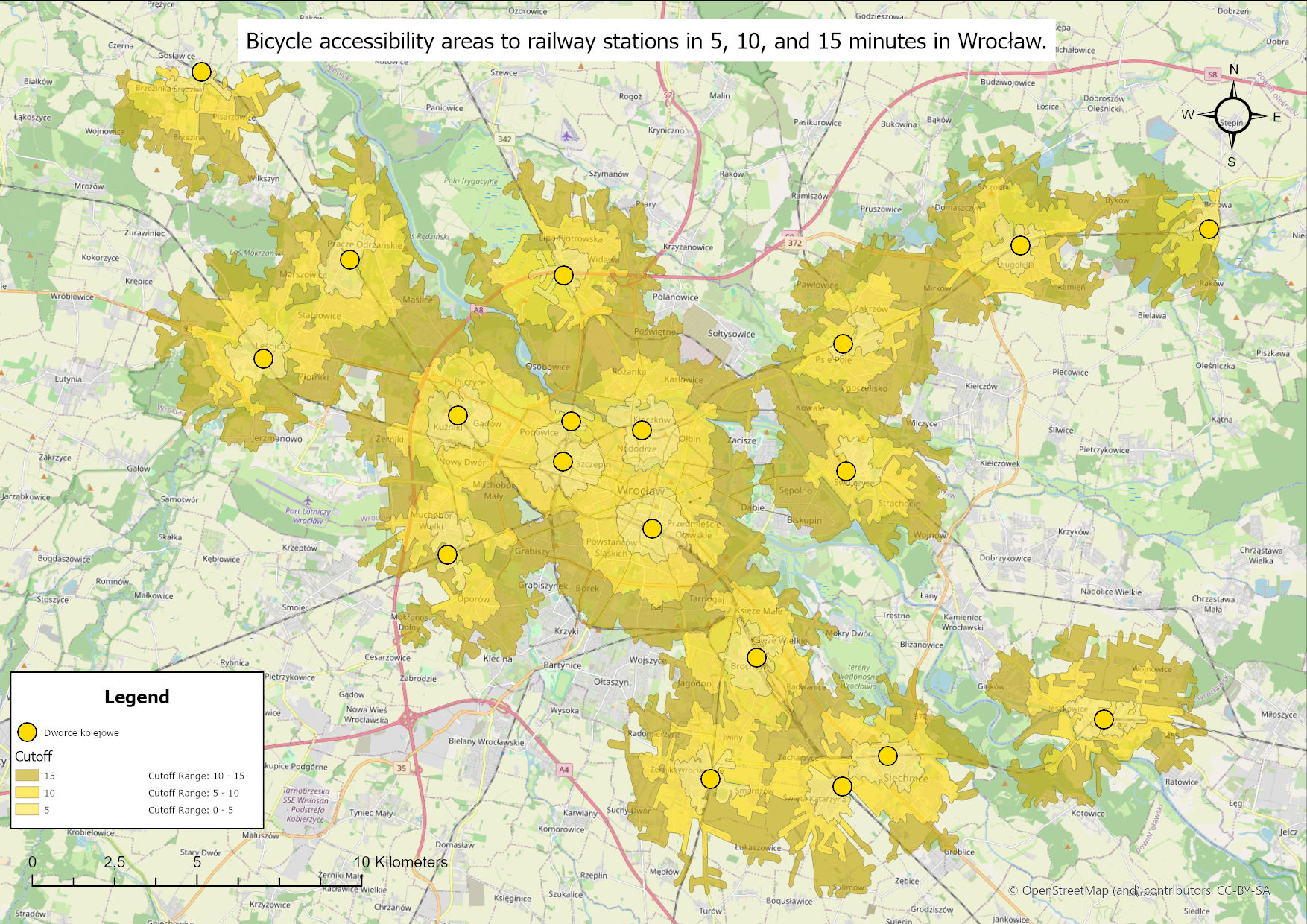
The analysis produced maps showing the bicycle travel range to railway stations in Wrocław within specified timeframes:

5-minute range

10-minute range

15-minute range
Discussion
The network analysis of bicycle access to railway stations in Wrocław provided valuable insights regarding accessibility and travel range within specified timeframes. This study offers a clear picture of several key aspects affecting cyclist mobility in the city.
Key Findings
- Identification of areas accessible within 5, 10, and 15 minutes by bicycle
- Detection of areas requiring bicycle infrastructure improvements
- Differentiation between city districts regarding accessibility
Limitations and Further Research
To enhance this analysis, future studies could consider:
- Route elevation profiles
- Different cyclist speeds
- Traffic conditions
- Peak hours
Summary
The analysis concludes that Wrocław's bicycle infrastructure is well-developed. The network of bicycle routes enables quick access to railway stations, suggesting that Wrocław invests in cycling infrastructure and strives to create a cyclist-friendly environment.
Traffic Reduction
Decreased number of cars on the roads
Ecology
Environmentally friendly sustainable transport
Health
Promotion of healthy lifestyle